NOIDA: The Uttar Pradesh government has established a panel to assess the jurisdiction of YEIDA, which encompasses 1,149 villages from Gautam Budh Nagar to Agra, covering an area of 3.35 lakh hectares—almost three times the combined area of Noida and Greater Noida, which is 1.12 lakh hectares.
The committee will consider reducing YEIDA’s scope to approximately 300 villages, aiming to balance long-term planning with immediate developmental requirements while ensuring that residents and investors in areas outside the approved master plans are not stuck awaiting necessary approvals or infrastructure.
YEIDA CEO RK Singh commented that the panel’s goal is to create a more feasible and actionable master plan. “It took the Noida Authority 50 years to develop 20,000 hectares. One can only imagine how much time would be required to develop over 80,000 hectares included in YEIDA’s current development plans,” Singh noted.
The challenge arises as a significant portion of YEIDA’s designated area remains unaddressed in its master plan, halting the formal mapping and layout for construction—this is vital for industries, educational institutions, and major projects looking to establish operations.
Proposals under review include a phased approach for development standardization. One suggestion is to empower district-level entities, such as zila panchayats, to permit industrial activity in villages outside the immediate master plan, while YEIDA maintains the power to approve layouts and impose development fees. Another possibility involves hiring consultants to develop corridor-based plans along state highways in six districts, facilitating selective approvals.
A more drastic option would involve de-notifying villages that are unlikely to develop for decades, although officials warn this could lead to uncontrolled growth.
Established in April 2001 as the Taj Expressway Industrial Development Authority, YEIDA currently oversees the largest development jurisdiction in Uttar Pradesh.
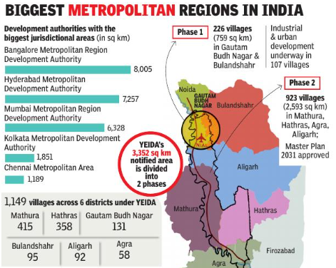
Originally, the notified area was 2,689 sq km but expanded to 3,352 sq km (or 3.35 lakh hectares) in 2023, covering 1,149 villages across six districts: Mathura (415 villages), Hathras (358), Gautam Budh Nagar (131), Bulandshahr (95), Aligarh (92), and Agra (58).
The region is divided into two phases. Phase 1 includes 226 villages across 759 sq km in GB Nagar and Bulandshahr, with industrial and urban development proceeding in 107 villages. Phase 2 encompasses 923 villages over 2,593 sq km in Mathura, Hathras, Agra, and Aligarh.
The Master Plan 2031 for Phase 2 was approved this year, allowing YEIDA to plan for four major urban centres: Raya (11,654 hectares), Tappal-Bajna (11,104 hectares), New Agra (12,200 hectares), and Hathras (9,000-10,000 hectares). Detailed project reports for Raya and Tappal-Bajna are prepared, while consultants are being engaged for Agra and Hathras, with full development expected to take 15-20 years.
CEO Singh reaffirmed that the committee’s purpose is not to constrict YEIDA but to enhance its functionality, ensuring that long-term planning does not leave residents and investors in limbo. With the review panel’s insights, the government aims to stimulate development in key villages while establishing a phased urbanization roadmap along the Yamuna Expressway corridor.
This review is projected to significantly influence ongoing development projects, including the Noida International Airport, Film City, Logistics Park, and industrial clusters, as it aims to render YEIDA’s master plan actionable and effective throughout its jurisdiction.