GURUGRAM: Haryana’s government has officially defined “forest” for the first time, establishing a clearer framework for environmental laws that were previously uncertain.
However, this definition is more restrictive than the Supreme Court’s guidance from a 1996 ruling, potentially excluding many areas that the same laws aim to protect.
A notification issued on August 18 by the state’s forest, environment, and wildlife department states that land parcels of at least 5 hectares (equivalent to 10 football fields) or 2 hectares adjacent to designated forests, must have a canopy density of at least 40% to be labeled as ‘forest.’
This effectively excludes small forest patches, areas of the Aravali hills with low vegetation density, scrublands, grasslands, and community lands from the definition of ‘forests.’
The criteria also rule out linear, compact, and agro-forestry plantations, and orchards outside designated forest areas, regardless of their size or density. This includes roadside green belts that may extend for several kilometers but are only a few meters wide.
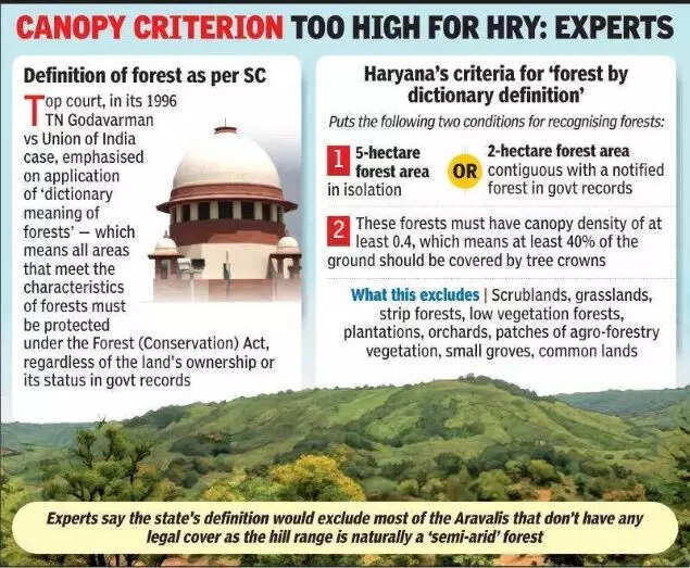
The notification specified that “a patch of land will be considered a forest if it meets the following criteria: a minimum area of 5 hectares, if isolated; or 2 hectares, if adjacent to government-notified forests, with a canopy density of 0.4 or more. However, all linear/compact/agro-forestry plantations and orchards outside government-designated forests will not be categorized as forest.”
This new definition comes nearly sixty years after the state’s establishment and is narrower than the Supreme Court’s ruling in the 1996 TN Godavarman vs Union of India case, which stated that forests should be identified based on their characteristics regardless of their official classification.
This broader understanding, termed ‘deemed forest,’ expanded the scope of the Forest (Conservation) Act, enabling the protection of various green areas from urban development and deforestation.
Experts have warned that this limited definition will overlook significant areas of the Aravalis from receiving legal protection. “This definition fails to account for the unique realities of the region. The Aravalis primarily consist of scrub forests with a canopy density of only 10% to 20%. This definition does not protect the habitats of our state bird, the black francolin, and state animal, the blackbuck, which thrive in grasslands. It seems tailored to benefit the builder lobby,” stated MD Sinha, a retired conservator of forests in Haryana (South).
Others noted that Haryana has the lowest forest cover among all Indian states at just 3.6% of its geographical area. “In the last 15 years, the state has been constructing six-lane roads in every district, leading to the destruction of strip forests. Over 90% of Haryana’s strip forests have been lost. We have only 5 to 7 block forests, which are also encroached upon,” said RP Balwan, a former conservator of forests in Haryana (South).
The Supreme Court had directed all states and Union Territories to define forests to prevent further loss of green cover, following a series of petitions challenging amendments to the Forest (Conservation) Act.
As cited in a 2011 case regarding environmental clearance for mining in Meghalaya, the court instructed states to form expert committees within a month to address the issue.
Principal Chief Conservator of Forests Vineet Kumar Garg informed TOI that state-appointed committees will survey landscapes, verify canopy cover, and apply the defined rules. “This process will determine how much of the Aravalis and other open lands receive legal protection under the Forest (Conservation) Act,” Garg explained.
In response to the narrowed definition, Garg mentioned that each state was tasked with creating its own definition. “The expert committee, led by the chief secretary, reviewed definitions from other states. Fifteen states adhered to the canopy density requirement of 0.4 or more. Haryana followed suit, applying this criterion to areas outside notified forests. Hence, this definition will not diminish protected areas,” he added.
Despite Haryana’s 1 lakh hectares of Aravali hills, over half (55,000 hectares) lack protection under the Forest (Conservation) Act.
This situation largely arises from ownership issues, where Aravali land has not been classified as ‘forest’ but remains under the revenue department, not the forest department.
The only protected Aravali lands are due to court rulings, such as sections 4 and 5 of the Punjab Land Preservation Act, 1990, and the 1992 Aravali Notification.
Safeguarding the Aravalis is vital for not just Haryana, but for most of north-west India, as it prevents the Thar desert from encroaching into the plains. The region is also home to a rich diversity of flora and fauna, including endangered species such as leopards, Indian pangolins, and white-rumped vultures.
Forest analyst Chetan Agarwal criticized the state’s definition, emphasizing that the Aravalis’ low rainfall has led to the adaptation of thorny and dry-deciduous vegetation. “It is regrettable that Haryana has adopted a minimum threshold of 40% canopy cover, similar to states like Goa, without considering the unique characteristics of the Aravalis. Areas with 10%-40% canopy cover should also be recognized as forest per dictionary meaning. This decision could pave the way for increased urbanization and mining in the region,” he concluded.